Within Marche UFOs
Could Rare Sea Surges Explain Adriatic Alarm?
The unusual 1978 sea surge shows how rare atmospheric events can produce alarming water behaviour without an underwater vehicle.
On this page
- The June 1978 Adriatic disturbance
- How meteotsunamis form
- What the event can and cannot explain
Page outline Jump by section
Introduction
A sudden withdrawal of the Adriatic, boats left on the bottom and water returning in damaging surges may sound like evidence of an underwater disturbance. The best-studied example, however, points mainly to the atmosphere. On 21 June 1978, a tsunami-like event affected the central and southern Adriatic, with the most destructive flooding at Vela Luka on the present-day Croatian coast and smaller anomalies reported along eastern Italy. Later numerical modelling showed that a fast-moving atmospheric pressure disturbance could have generated and amplified the waves without an earthquake, submarine vehicle or other extraordinary underwater cause.[jadran.izor.hr]jadran.izor.hrVucetic etal PCE 2009The Great Adriatic flood of 21 June 1978 revisited: An overview of the reports…
For Marche’s UFO history, the event matters as a caution rather than as a direct explanation for every maritime sighting. It demonstrates that the Adriatic can behave dramatically under rare atmospheric conditions, even when the local weather appears relatively calm. Yet the documented 1978 effects did not clearly extend into Marche: the strongest review found no eyewitness reports north-west of Giulianova, just beyond the regional boundary. The case therefore supplies a credible natural mechanism for evaluating sea-anomaly stories, but not evidence that a particular Marche report has been solved.[jadran.izor.hr]jadran.izor.hrVucetic etal PCE 2009The Great Adriatic flood of 21 June 1978 revisited: An overview of the reports…
The June 1978 Adriatic disturbance
The first destructive surge reached Vela Luka at about 04:15 UTC on 21 June. Water overtopped quays, entered waterfront buildings, broke walls and snapped mooring lines. It then retreated sufficiently to expose the upper bay and leave vessels grounded. Repeated oscillations followed, culminating at about 07:00 UTC in a reported crest-to-trough range of roughly six metres. No tide gauge was operating inside the bay, so this maximum was reconstructed from eyewitness accounts, photographs and flood marks on buildings rather than from a continuous instrumental record.[jadran.izor.hr]jadran.izor.hrVucetic etal PCE 2009The Great Adriatic flood of 21 June 1978 revisited: An overview of the reports…
The physical effects were nevertheless substantial and independently visible. Photographs show the harbour almost emptied at low water and streets flooded at high water. The ferry Vis reportedly remained outside the bay after its captain observed unusually strong currents and inundation through binoculars. There were no deaths and only minor injuries, but homes, businesses, boats and port infrastructure were damaged. Contemporary estimates of wave height varied widely, illustrating why later researchers treated the six-metre figure as a reconstructed maximum rather than an exact instrument reading.[jadran.izor.hr]jadran.izor.hrVucetic etal PCE 2009The Great Adriatic flood of 21 June 1978 revisited: An overview of the reports…
The disturbance was not confined to Vela Luka. Flooding, rapid currents or unusual oscillations were reported around Dubrovnik, Lastovo, Vis, Hvar and other parts of the eastern Adriatic. Tide gauges recorded smaller high-frequency sea-level changes at several stations, confirming that this was a basin-scale episode whose local severity depended heavily on coastal shape. Northern Adriatic instruments showed little activity, consistent with the absence of reports from that sector.[jadran.izor.hr]jadran.izor.hrVucetic etal PCE 2009The Great Adriatic flood of 21 June 1978 revisited: An overview of the reports…
On the Italian side, accounts described alternating withdrawal and flooding from Giulianova southwards through Abruzzo, Molise and Apulia. At Ortona the sea reportedly receded by about 15 metres before returning; at Fossacesia, Vasto and other locations there were reports of exposed seabed, stranded fish, inundation or strong currents. Near Bisceglie, witnesses described a much larger harbour wave, while at Vieste a sudden withdrawal was followed by damaging water movement. The reports varied in precision and were not supported everywhere by tide-gauge records, but their timing and geographical pattern helped researchers test competing explanations.[jadran.izor.hr]jadran.izor.hrVucetic etal PCE 2009The Great Adriatic flood of 21 June 1978 revisited: An overview of the reports…
This geographical limit is important for Marche. The later scientific reconstruction states that no eyewitness reports described unusual waves north-west of Giulianova. Giulianova lies in Abruzzo, immediately south of Marche, so the surviving evidence does not establish that the 1978 surge noticeably affected ports such as San Benedetto del Tronto, Ancona or Pesaro. The event belongs to the physical history of the wider Adriatic, but claims that it directly produced a Marche maritime incident would require separate local documentation.[jadran.izor.hr]jadran.izor.hrVucetic etal PCE 2009The Great Adriatic flood of 21 June 1978 revisited: An overview of the reports…
How meteotsunamis form
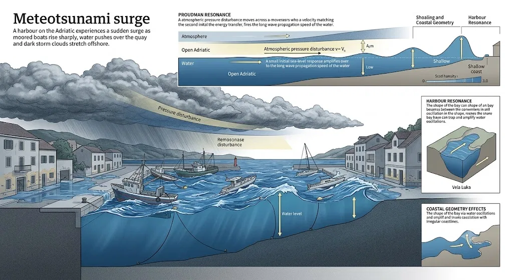
A meteotsunami is a long sea wave generated by atmospheric disturbance rather than sudden movement of the seabed. Its source can be a rapid pressure change, atmospheric gravity wave, storm front or convective system travelling above the water. The initial displacement may be modest. The danger arises when the atmospheric disturbance and the ocean wave travel in a favourable relationship, allowing energy to pass repeatedly from the air into the sea.[NOAA Institutional Repository]repository.library.noaa.govInstitutional Repository Addressing the Meteotsunami Risk in the United StatesThis allows sufficient energy transfer from the atmosphere to the water, resulting in amplification of the…
The key process proposed for 1978 is known as Proudman resonance. In simplified terms, amplification occurs when a travelling atmospheric pressure disturbance moves at roughly the same speed as a long wave in the water beneath it. Instead of producing only the small sea-level response normally expected from a few millibars of pressure change, the moving disturbance continues to push the wave along its path. The 2010 modelling study found that an atmospheric perturbation of only a few millibars, travelling across the middle and southern Adriatic at the reconstructed speed and direction, could generate sea-level variability of several metres inside Vela Luka Bay.[jadran.izor.hr]jadran.izor.hrOrlic etal JGR 2010jc005777 1..19…
That does not mean the open sea rose six metres everywhere. Several stages of amplification were involved:
- Atmospheric forcing generated a travelling long wave.
- Resonant coupling allowed the wave to grow as it crossed favourable water depths.
- Shoaling and coastal geometry increased its height near shore.
- Harbour or bay resonance caused water to oscillate strongly within particular enclosed locations.
Vela Luka is especially vulnerable because its long, narrow bay can magnify incoming oscillations. This explains why one harbour suffered severe flooding while open-coast tide gauges or more exposed locations recorded much smaller movements. Similar resonance effects are a recognised reason why meteotsunamis can be hazardous in selected bays while passing almost unnoticed elsewhere.[sciencedirect.com]sciencedirect.comDestructive meteotsunamis along the eastern Adriatic coastby I Vilibić · 2009 · Cited by 143 — This paper will overview the…
The visual behaviour can be deeply misleading. A harbour may drain rapidly, exposing mud or seabed, before water races back. Boats may move without an obvious local wind, currents may reverse several times and separate surges may arrive minutes apart. To an observer unfamiliar with long-wave oscillations, the cause can appear to be beneath the surface. In reality, the energy may have entered the sea hundreds of kilometres away or through a pressure disturbance too subtle to be recognised as dangerous weather at the affected coast.[jadran.izor.hr]jadran.izor.hrVucetic etal PCE 2009The Great Adriatic flood of 21 June 1978 revisited: An overview of the reports…
Why the atmospheric explanation prevailed
Researchers initially considered several possible causes. One proposal connected the event to a magnitude 6.5 earthquake near Thessaloniki on the previous evening. Another suggested a submarine landslide off the Italian coast between Termoli and Vasto. Meteorological explanations included waves generated by a passing cyclone and resonant forcing by an atmospheric gravity wave crossing from Italy towards the eastern Adriatic.[jadran.izor.hr]jadran.izor.hrVucetic etal PCE 2009The Great Adriatic flood of 21 June 1978 revisited: An overview of the reports…
The earthquake theory struggled with the observed timing. Later analysis calculated that shallow-water waves from the suggested Aegean source should have reached Vela Luka much sooner than the approximately eight-hour interval that was observed. It also did not naturally reproduce the close relationship between the timing of anomalies on the western and eastern Adriatic coasts. No earthquake occurred within the Adriatic itself at the relevant time.[jadran.izor.hr]jadran.izor.hrVucetic etal PCE 2009The Great Adriatic flood of 21 June 1978 revisited: An overview of the reports…
The landslide proposal was never supported by a securely identified slide with a known location, size and time. Researchers also noted that mapped recent slope failures in the relevant south-western Adriatic margin appeared too limited to generate the recorded basin-wide pattern. A hypothetical landslide could not be excluded merely because no one saw it, but without a mapped source it remained less testable and less economical than the atmospheric mechanism.[jadran.izor.hr]jadran.izor.hrVucetic etal PCE 2009The Great Adriatic flood of 21 June 1978 revisited: An overview of the reports…
The strongest support for a meteotsunami came from combining historical pressure observations, tide gauges, witness timing and numerical modelling. Researchers reconstructed an atmospheric gravity wave moving from the Italian side across the Adriatic during the crucial morning hours. Ocean modelling then reproduced the broad geographical distribution and showed that resonant atmospheric forcing could create much larger oscillations inside Vela Luka than the original pressure change alone would suggest. The model did not reproduce every detail perfectly because the 1978 pressure disturbance was poorly sampled, but its timing and wave-height relationships strongly favoured a mesoscale atmospheric source.[jadran.izor.hr]jadran.izor.hrOrlic etal JGR 2010jc005777 1..19…
The classification therefore changed in strength over time. Early catalogues could reasonably list the event as a tsunami of unknown origin because the source was unsettled. The 2009 review judged travelling atmospheric waves the most plausible explanation but called for numerical confirmation. The following year’s modelling supplied that missing step and concluded that the surge was generated by a mesoscale atmospheric disturbance. Some uncertainty remains over the exact form and strength of the original pressure wave, not over whether a hidden underwater craft is needed to explain the event.[jadran.izor.hr]jadran.izor.hrVucetic etal PCE 2009The Great Adriatic flood of 21 June 1978 revisited: An overview of the reports…
What the event can and cannot explain
The 1978 episode provides a strong natural comparison for reports involving rapid changes in water level, inexplicable harbour currents, exposed seabed, repeated surges or boats moving during apparently calm local conditions. When several distant coastal locations report anomalies in sequence, investigators should examine atmospheric pressure records, thunderstorms, tide gauges and harbour resonance before considering an underwater source.
It also shows why witness honesty is not the central issue. People at Vela Luka correctly reported extraordinary behaviour: the sea really did flood streets, retreat and return. Their observations became easier to interpret only after records from both sides of the Adriatic were assembled and tested against physical models. A dramatic account can therefore be substantially accurate while the witness’s initial theory about its cause is wrong.
For Marche UFO research, however, the explanatory reach must not be stretched. The 1978 event does not by itself account for lights above the sea, structured objects, radar returns or alleged close encounters. Nor can it explain a reported water disturbance on a different date merely because both occurred in the Adriatic. A convincing meteotsunami interpretation requires correspondence in time, weather conditions and coastal behaviour.
Useful indicators would include:
- a rapid sequence of sea withdrawal and return rather than a single local splash;
- similar anomalies reported along a wider stretch of coast;
- pressure jumps or fast atmospheric disturbances crossing the sea;
- oscillations lasting tens of minutes or several hours;
- stronger effects inside resonant ports and bays than on neighbouring open beaches;
- no matching earthquake or verified submarine landslide.
Marche’s relatively open western coastline also differs from the deeply indented eastern Adriatic bays where the most extreme amplification occurs. That does not make atmospheric sea anomalies impossible along Marche, but it makes a Vela Luka-scale harbour response less automatic. Local bathymetry, port geometry and the path of the atmospheric disturbance would have to align favourably. The 1978 record itself reinforces this selectivity: marked effects were documented south of Marche while nearby stretches farther north produced no surviving eyewitness reports.[jadran.izor.hr]jadran.izor.hrVucetic etal PCE 2009The Great Adriatic flood of 21 June 1978 revisited: An overview of the reports…
The safest conclusion is therefore limited but useful. Rare atmospheric events can make the Adriatic rise, retreat and surge in ways that look as though something powerful has moved underwater. The June 1978 disturbance is the clearest regional demonstration of that mechanism. It weakens extraordinary interpretations of unsupported sea-anomaly stories, while leaving individual Marche UFO cases to be judged on their own dates, witnesses, records and physical evidence.
Amazon book picks
Further Reading
Books and field guides related to Could Rare Sea Surges Explain Adriatic Alarm?. Use these as the next step if you want deeper reading beyond the article.
Tsunami: The Underrated Hazard
Comprehensively describes the nature and process of tsunami, for students and researchers, and general public.

Waves in Oceanic and Coastal Waters
Describes physical and statistical aspects of waves for graduates, researchers and engineers.
The AMS Weather Book
America has one of the most varied and dynamic weather systems in the world. Every year, the Gulf Coast is battered by hurricanes, the Gr...
eBay marketplace picks
Marketplace Samples
Live-tested eBay searches with available results related to this page.
Selected fromUFO poster oneBay.co.uk.

Current eBay listing
I Want To Believe UFO Poster Giclée Fine Art Heavyweight Print


Current eBay listing
VINTAGE UFO FLYING SAUCERS COMIC ADVERTISING A2 POSTER PRINT

Endnotes
1.
Source: jadran.izor.hr
Title: Vucetic etal PCE 2009
Link:https://jadran.izor.hr/~vilibic/meteotsunami/Vucetic-etal_PCE_2009.pdf
Source snippet
The Great Adriatic flood of 21 June 1978 revisited: An overview of the reports...
Published: June 1978
2.
Source: jadran.izor.hr
Title: Orlic etal JGR 2010
Link:https://jadran.izor.hr/~vilibic/meteotsunami/Orlic_etal_JGR_2010.pdf
Source snippet
jc005777 1..19...
3.
Source: repository.library.noaa.gov
Title: Institutional Repository Addressing the Meteotsunami Risk in the United States
Link:https://repository.library.noaa.gov/view/noaa/28470/noaa_28470_DS1.pdf
Source snippet
This allows sufficient energy transfer from the atmosphere to the water, resulting in amplification of the...
4.
Source: sciencedirect.com
Link:https://www.sciencedirect.com/science/article/abs/pii/S1474706509001089
Source snippet
Destructive meteotsunamis along the eastern Adriatic coastby I Vilibić · 2009 · Cited by 143 — This paper will overview the...
5.
Source: repository.library.noaa.gov
Title: Institutional Repository A METEOTSUNAMI CLIMATOLOGY ALONG THE U.S
Link:https://repository.library.noaa.gov/view/noaa/50029/noaa_50029_DS1.pdf
Source snippet
by G Dusek · 2019 · Cited by 58 — Further amplification of the wave can occur due to harbor resonance (Raichlen 1966), in which the shape...
6.
Source: sciencedirect.com
Link:https://www.sciencedirect.com/science/article/abs/pii/S1474706509001065
Source snippet
The Great Adriatic flood of 21 June 1978 revisitedby T Vučetić · 2009 · Cited by 59 — This paper describes an extraordinary tsunami-like...
Published: June 1978
7.
Source: repository.library.noaa.gov
Title: noaa 64707 DS1
Link:https://repository.library.noaa.gov/view/noaa/64707/noaa_64707_DS1.pdf
8.
Source: repository.library.noaa.gov
Title: noaa 57819 DS1
Link:https://repository.library.noaa.gov/view/noaa/57819/noaa_57819_DS1.pdf
9.
Source: repository.library.noaa.gov
Title: noaa 13013 DS1
Link:https://repository.library.noaa.gov/view/noaa/13013/noaa_13013_DS1.pdf
10.
Source: jadran.izor.hr
Link:https://jadran.izor.hr/~vilibic/vela_luka/presentations/Vilibic.pdf
11.
Source: projekti.pmfst.unist.hr
Link:https://projekti.pmfst.unist.hr/floods/meteotsunamis/
12.
Source: isprambiente.gov.it
Title: Aspetti geostrutturali di evoluzione ambientale
Link:https://www.isprambiente.gov.it/contentfiles/00004700/4759-c3070-m3-u2.pdf
Additional References
13.
Source: youtube.com
Title: Watch a meteotsunami strike a Lake Michigan shoreline
Link:https://www.youtube.com/watch?v=GgW_C3Qvugw
Source snippet
What Is a Meteotsunami? Rare Phenomenon in the Great Lakes Explained...
14.
Source: researchgate.net
Link:https://www.researchgate.net/publication/367554293_Meteorological_Tsunamis_in_the_Adriatic_Sea
15.
Source: academia.edu
Link:https://www.academia.edu/86774946/Destructive_meteotsunamis_along_the_eastern_Adriatic_coast_Overview
16.
Source: researchgate.net
Link:https://www.researchgate.net/figure/Photos-of-the-Great-Vela-Luka-meteotsunami-of-21-June-1978-after-Vucetic-and-Barcot-2008_fig7_318654047
Published: June 1978
17.
Source: earth-prints.org
Link:https://www.earth-prints.org/entities/publication/1e73d7bb-eef8-4720-8c74-3929de9f8a5d
18.
Source: youtube.com
Link:https://www.youtube.com/shorts/dIZtbmdiLJ4
19.
Source: youtube.com
Title: What is a Meteotsunami?
Link:https://www.youtube.com/watch?v=lx3rTxu8gGw
Source snippet
Watch a meteotsunami strike a Lake Michigan shoreline...
20.
Source: youtube.com
Link:https://www.youtube.com/watch?v=WeTcoEuXEZo
Source snippet
Jadranski tsunami - plima, Vela Luka 1978...
21.
Source: infoplaza.com
Title: understanding and impact of meteo tsunamis on offshore operations
Link:https://www.infoplaza.com/en/blog/understanding-and-impact-of-meteo-tsunamis-on-offshore-operations
22.
Source: royalsocietypublishing.org
Title: Are meteotsunamis an underrated hazard Are
Link:https://royalsocietypublishing.org/rsta/article/373/2053/20140377/115013/Are-meteotsunamis-an-underrated-hazard-Are
Source snippet
Results from idealized...Read more...